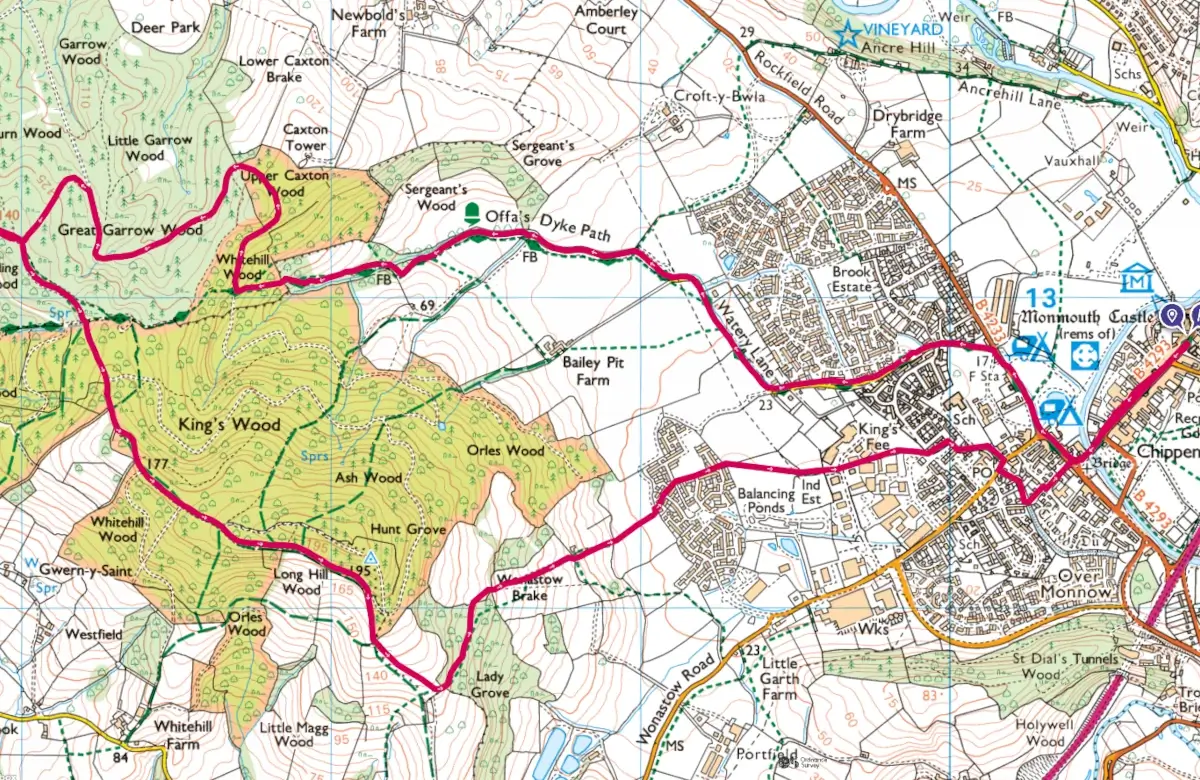
This walk takes you along part of the Offa’s Dyke national footpath (ODP) up to Kingswood. There are views of distant mountains and possible sightings of Red Kites and Deer. There is the option of a slightly shorter 6 mile route.
Leave Agincourt Square and the Charles Rolls statue and proceed down Monnow St until you arrive at the 13th century Old Monnow Bridge
Cross the bridge and turn right on Drybridge St, following signs for the ODP. Proceed straight on, passing the Bridges Centre and then the Ambulance Station on your left.
Turn left onto Watery Lane and stay on this tarmac lane for a total of 0.6 miles
At the end of Watery Lane, at the sign“Private Drive Bailey Pitt Farm”, go right into the field, still following the ODP. Proceed with trees on your right for 550 yards. Still following the ODP you will cross a footbridge on your right and proceed up hill.
Keeping the trees on your right, proceed for 550 yards to a fingerpost pointing right to another footbridge.
Follow the path, with a beck on your left, for 650 yards. As the path steepens, ignore the first (path) crossroads; you will immediately reach a major junction with a forest track.
Turn right on this wide track, leaving the ODP, and walk slightly uphill as the track meanders into the Kingswood. Look out for Red Kite overhead and deer in the undergrowth from this point. After 450 yards, as the track bends left, you will see a second branch off to the right. This is an optional detour to Caxton Tower (access to which is restricted by fencing). One can see the tower and get some fine views of the countryside towards Rockfield and Skenfrith by traversing to the left at the fence.
Returning to the main track, turn right and carry on for about 0.6 miles until the trees open out and you reach a junction.
Turn left uphill for 350 yards. As the track bears left and flattens out, look out for a narrow, sometimes muddy, path off to the right, passing through trees for 100 yards.
The trees open out, giving fine views of Skirrid Fawr, Sugarloaf and the more distant Brecon Hills and Black Mountains. This is an ideal spot for coffee and sandwiches as you admire the views and enjoy the peace and quiet;
Retrace your steps to the track and turn right. After 550 yards you reach a crossroads with the ODP. A left turn here follows the ODP back to Monmouth for a slightly shorter walk of 6 miles.
To continue, proceed forward and uphill, straight on at a junction with another track, for a total of 1500 yards. Keep following the main track, ignoring multiple paths and bridle ways left and right, eventually you will see occasional views to your right towards the Blorenge mountain in the distance.
When you reach a bridle path finger post, bear right at 30 degrees, taking the bridle path down through trees for 150 yards. When you reach the gate, take a moment to take in the fine views across the Trothy Valley from the National Trust Kymin and back towards the Blorenge;
After taking in the views, proceed downhill along a line of tall oak trees, towards the hedge at the bottom of the field. Do not veer right, but look for a gate/stile on the left in the corner of the hedge. The path descends through Lady Grove Wood. At the exit stile, keepright then cross a double stile.
Keep heading downhill through fields for 650 yards, where the spire of St Mary’s Priory church can be seen in the distance. Keep descending, heading for the spire over two more stiles, until you reach a third stile which gives access to the new Kingswood Gate housing development .
Proceed along the road, until it bends left and the footpath re-appears. Cross two estate roads and proceed through a gate over a footbridge and follow the path as it bears right across a field and then becomes narrower. Cross a road and keep following the narrow path as it passes light industry and houses.
Follow the tarmac Williams Field Lane, cross Wonastow Road at the zebra crossing and proceed forward to the medieval Clawdd-du Bridge. Turn left over the bridge and return to Drybridge St, cross the road to the Old Monnow Bridge and follow Monnow Street back the Shire Hall.


