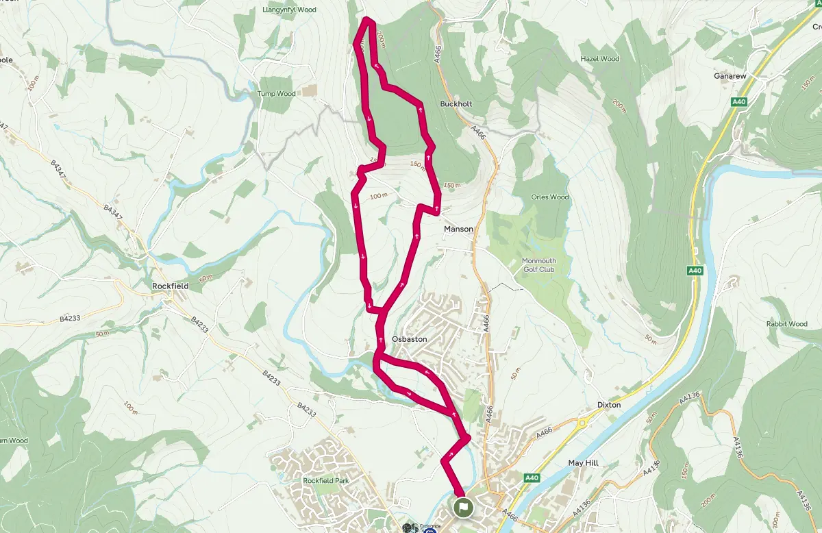
The walk takes you through ancient woodland in a once thriving centre of forestry industry. On the return leg you will enjoy views of Monmouth town, the Abergavenny mountains and the Monnow valley.
From Agincourt Square go up Castle Hill towards the castle. Take the first turning on the right and follow this lane down steps to Tibbs Bridge over the River Monnow. Cross the bridge into Vauxhall Fields and carry on to a crossroads of paths where you turn right and cross the Monnow again at Inglis Bridge. At the main road, Osbaston Road, turn left. Stay on this road for ½ mile passing Monnow Mill and a school on the left.
Shortly after passing Lancaster Way, look out for a lane on the right (immediately after the driveway leading to Great Osbaston)with a sign to Manson Lane. Follow the lane to the left of the house and enter the field. Cross the field and bear right at the hedge. Keeping the hedge on your left head uphill ignoring a track on the left eventually arriving at a tarmac road, Manson Lane.
Turn right and take the first turn on the left, signposted Buckholt Wood (look carefully, the sign may be obscured by the hedge!). Where the concrete drive ends, take the footpath straight ahead and continue uphill to a junction with main tracks. Turn left on the main track, ignoring a path immediately on the left and head uphill through the wood. Stay on the main track for ¾ mile, ignoring several paths off to the left and right. As you walk along this peaceful track enjoy the birdsong and watch out for deer grazing in the woods.
After a stile and gate turn left on the tarmac road (Manson Lane) and after 250 yards turn left back into the woods via a metal gate. Follow this path for ½ mile until it starts to descend and you seea path on the right which turns sharply back on itself and heading downhill. Follow the steep path with some steps to a stile at a fence at the edge of the woods.
Crossing into the field, Monmouth comes into view on your left and, straight ahead lie the Abergavenny mountains, the Skirrid and the Blorenge. Watch out for the buzzards that circle the woods and fields in this area.
Heading downhill, follow the left hand hedge line at first and after 100 yards bear right toward the corner of the field, heading for the farm buildings just beyond. At the hedge cross a stile and footbridge onto Manson Lane.
Turn right and then left through a wooden gate just before Great Manson Hall. Follow the farm boundary hedge on your right and take either the gate or gap into the next field. Head for the woods over the brow of the hill and bear left to a gap in the fence and continue downhill to a gate in the corner of the field. Beyond the gate, keeping to the edge of the field, bear right at the end of the wood, through a gap and turn left keeping the hedge on your left. Follow the hedge downhill until you reach a small stream. Cross the stream and follow the track uphill to a field and turn right along the field edge. After 100 yards follow the footpath as it bears left across the field and into a track down to the main road.
Turn left and then right through a gate. Follow the path between the hedge and the old vineyard to a stile near the river. Follow the river past the hydroelectric power plant to the a gate leading onto Forge Road. Continue along Forge Road to meet OsbastonRoad . Retracing the route back to the start, turn right passing Monnow Mill and turn right to cross Inglis Bridge into Vauxhall Fields. Turn left at the crossroads of paths and cross Tibbs Bridge. Follow the track up steps to Castle Hill. Turn left to reach Agincourt Square.