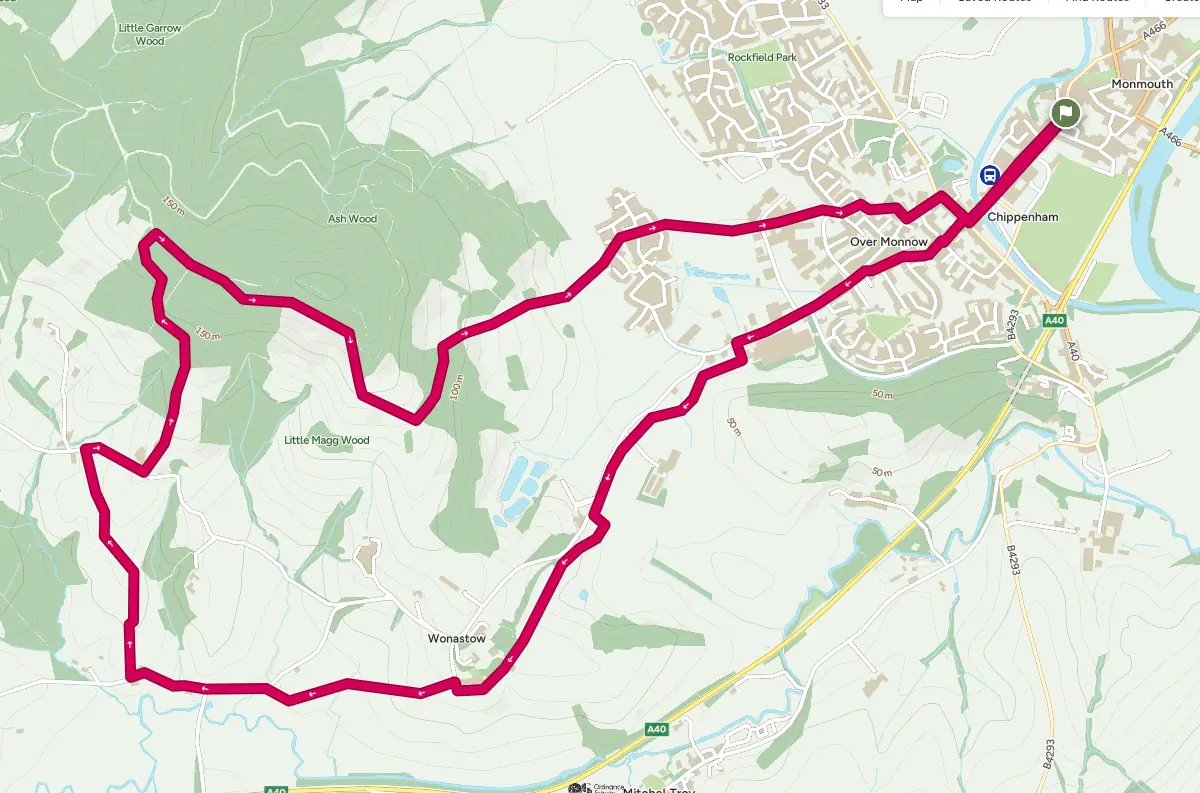
After leaving town the walk takes you through fields to Wonastow and then along quiet country lanes with views of the beautiful Trothey Valley before a walk through peaceful woodland.
From Agincourt Square, walk down Monnow Street and cross over the old Monnow bridge. Cross over the main road into Goldwire Lane at the side of the Green Dragon. At the end of Goldwire Lane cross the mediaeval bridge over Clawdd-Du (Black Dyke)* and continue straight ahead to reach Elstob Way. Cross Elstob Way and follow the footpath past the adult learning centre and houses to reach Wonastow Road. Bear left, keeping a hedge and the main road on your right and houses on your left. Stay on Wonastow Road until you reach a stile on the left, immediately after the Tri-Wall factory.
Crossing the stile you soon see a stile on the right. Over this stile and two more. After the second style you may wish to follow the hedge boundary to your right if the field has crops in it. Passing to the left of Little Garth Farm, you come to another stile at the junction of two hedges . Cross here and bear right towards the hedge along the roadside. Follow this hedge and cross a driveway and more stiles passing Wonastow Lodge before reaching Wonastow Court. Go between the farm buildings. As the road bears right keep straight ahead with a hedge on your left. As you approach the corner of this hedge, bear right uphill until a lone tree in the field comes into view. Pass to the left of the tree to a bridge. Cross the bridge and a stile and head diagonally left across the field to a stile in the corner. Cross the stile and turn right to a gate and stile leading to a tarmac road, Jingle St. This road takes its name from the sound of bells jingling on the harnesses of passing horses in times gone by.
Turn left along Jingle St for 500 yards and as it starts to descend turn right up a track to a pair of gates. Taking the left hand gate follow the hedge on your right to a stile crossing this hedge. Carry on in the same direction but with the hedge now on your left. At the next stile bear left diagonally across the field and cross stile. Now turn right and keep the hedge on your right to cross three more stiles before crossing a small field to reach the road, via a stile located to the right of a group of small trees alongside the hedge.
Turn right to reach Whitehill Farm and turn left up a bridleway track for 500 yards before entering Whitehill Woods. Follow the main track as it climbs to reach a T- junction and turn right. Follow this peaceful track for about 0.5 miles, ignoring paths to left and right, until you come to a main track downhill on the right, marked bridleway with a finger post.
Take this downhill bridleway to a gate into the open field and watch out for buzzards that enjoy the combination of woods, fields and hillside. Bear left diagonally downhill, keeping to the left of a broken line of trees within the field, to a gate and stile in the corner of the field and enter Lady Grove.
Follow the track through the wood until you reach a stile leading into a field. Bear right along the edge of this field to find two stiles on your right. Cross the stile. Monmouth church spire now comes into view. Head for the spire through fields and over stiles until you come to a hedge at Kingswood housing estate
Crossing a stile into Acer Way, go straight ahead on tarmac pedestrian paths until you reach a field.
Cross the field to a gate and carry on until you arrive at an industrial estate. Cross the road and follow the path which passes between high metal fences. Follow this to an open area, passing to the left of a children’s playground to a gap onto a tarmac path. Turn right and follow the path which becomes Williams Field Lane, passing houses and a school before reaching Wonastow Road. Turn left to reach a roundabout and turn right. After 150 yards, at the next roundabout turn left to the old bridge and follow Monnow St back to Agincourt Square.
* The monument comprises the remains of a stretch of the medieval town defences. It consists of a long, curved, steep-sided ditch, 3m to 4m wide at the base and 2m deep, orientated roughly NW/SE to the W of the river Monnow. The ditch, which records show was also called the Black Dyke, was built to provide protection for the suburb of Overmonnow, which was an important iron and wool working centre during the medieval period. Originally there would have been a large bank on the inner (E) side of the ditch, possibly surmounted by a wooden palisade, but the ditch has been flattened. A stone bridge crosses the N end of the ditch, this is medieval in date and would have carried a road across the ditch towards the Monnow Bridge (MM008).
The monument is of national importance for its potential to enhance our knowledge of medieval defensive organisation and of the growth of towns. The monument forms an important element within the wider medieval context and the structure itself may be expected to contain archaeological information in regard to chronology, building techniques and functional detail.
The scheduled area comprises the remains described and areas around them within which related evidence may be expected to survive.
Source: Cadw