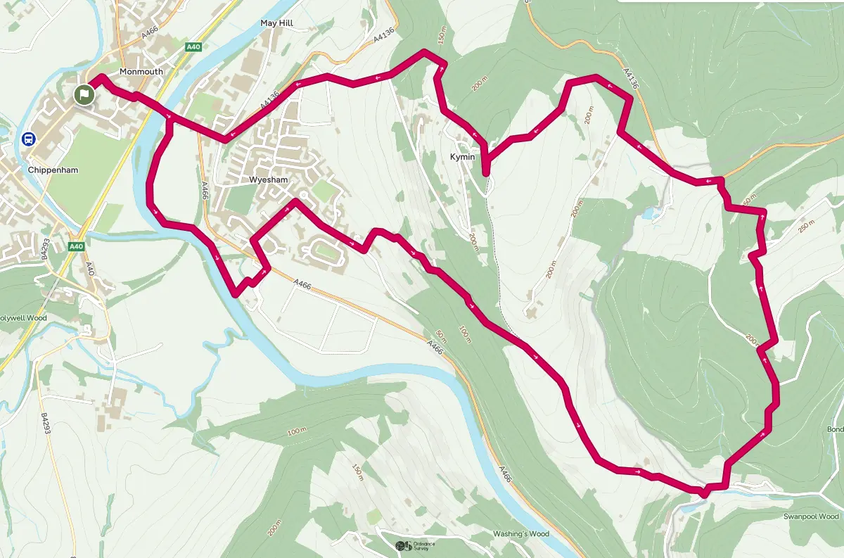
Commencing with a riverbank walk and then a climb through woodlands this walk leads to views overlooking Monmouth town and panoramic views of the Wye Valley and the Brecon Beacons. The Kymin is a prominent hill which is the home to the 18th century Round House and Naval Temple.
Leave Agincourt Square via Church St. At the junction, turn right down St Mary’s St and at the end turn left and immediately right into Wyebridge St. Use the underpass to cross the A40 dual carriageway and cross the Wye Bridge. After the river crossing turn right into the car park for the Monmouth School sports ground. Pass the pavilion on your left to join the Wye Valley Walk, which follows the bank between the playing fields and the river. Continue past the confluence of the Monnow and Wye, passing under a disused iron railway bridge. Here the path narrows and skirts the river bank more closely, passing under the stonework of a second railway bridge, now dismantled.
Immediately after crossing a side-stream on a footbridge of railway sleepers, climb the steps on the left to follow the stream past the sewage treatment works and across the open field beyond. Cross the A466 and up the slight rise beyond to meet the course of the disused Wye Valley Railway, now discernible only by its raised course extending over the fields to the right. Turn left and pass a large bramble patch into a small housing estate. Follow this road for 75 metres and then to Wyesham Avenue. Follow this uphill to the junction with Wyesham Road, with St James’s church on your left. Turn right and follow Wyesham Road past Kymin View primary school until the end of the housing on the right-hand side of the road.
Here turn left uphill along Wyesham Lane, which bends right then climbs south-east, giving some excellent views over Wyesham towards Livox woods and Penallt Old Church, with the Trothy valley beyond leading towards Raglan and Abergavenny. At the entrance to Sky Farm on the left the lane becomes an unmetalled track. Continue up through the woods past Harper’s Grove until emerging by Redbrook Equestrian’s stables at Cockshoot Ash Barn, some 175m (574 feet) above sea level and 150m above the Mayhill hotel. Here the track becomes wider and starts to descend along the ridge towards Upper Redbrook, giving magnificent views over the Wye valley and towards Newland. At Jamie’s Farm, on the left, the descent accelerates but the road surface improves. However, as the first house is approached, with the lane bending right, continue slightly left straight on down a poorly waymarked, very rough and often damp footpath. This drops steeply behind several houses before emerging onto a minor road.
Turn left, follow the road for a few yards round a right-hand bend, then veer to the left up a footpath. This soon turns uphill. Follow the path upwards – very steeply in parts – through the woods, crossing a disused railbed then two forest roads, until a T-junction is reached by Knockalls Lodge. Turn right through the gate, then keep left, continuing upwards (northwards) until a further settlement is reached at Staunton Meend. Cross the track and follow the footpath past Buck Stone Lodge on the left. Continue uphill keeping close to the stone boundary wall with the woods on your left. At the top of the hill, pass through one of the two gates to reach the Buck Stone at 279m (915 feet) above sea level, with immense views out to the West.
Return southwards on the wood side of the stone boundary wall, then follow the footpath as it bears downhill to the right into open woodland with few clearly defined paths. On reaching the west side of the wood, aim for the gap in the boundary wall where a footpath leaves the wood. After crossing the wall turn immediately right onto the footpath marked by a Waymarker on the telegraph pole. Follow this path downhill on the edge of the wood. After 200m there is a footpath crossing, turn left downhill. After a further 200m follow the footpath downhill with the fence (fallen down in places) on your right to emerge onto the A4136.
Turn left, taking advantage of a layby formed in previous widening to minimise time spent on this busy road, pass the entrance to Broadstone Camping on your left, then fork left into a quiet lane signed as No Through Road. Follow this lane until it turns sharply left; here go sharp right instead (ignoring the footpath sign pointing straight ahead), climbing a short ramp to follow a footpath through the wood until this reaches an unmetalled road at its junction with the A4136. Turn left and follow this uphill until reaching a gate on the left leading to an open field. Follow the path up through this field, though a belt of trees and a second field ending in a gate to the National Trust’s Kymin at just over 250m (820 feet) – celebrated as a dining box used amongst others by Admiral Lord Nelson, with magnificent views over Monmouth to the Sugar Loaf and beyond.
Returning to the north of the Kymin, immediately after passing a wooden outbuilding, follow the stepped path steeply down though Beaulieu Wood, keeping right when this path divides, and then again when it reaches the boundary of a house and garden. Follow the boundary down to a gate onto a private road. Turn right on this road, then after it bends to the left, fork right onto a public footpath between open fields. When this regains the woodland, turn left onto a track – which is Offa’s Dyke path – and follow this down through Garth Wood to reach the Kymin Road.
Turn right on this road, and after 500m where it bends right, continue straight ahead along the private road for about 100m until the Offa’s Dyke path veers off to the right. Follow this path down until it converges with the A4136. Follow this road as it bears right in front of the Mayhill Hotel and then over a roundabout and the Wye Bridge before using the underpass to cross the A40. Carry on to the end of Wyebridge St and turn left then right into St Mary’s St. At the top of St Mary’s St turn left into Church St and follow this back to Agincourt Square.