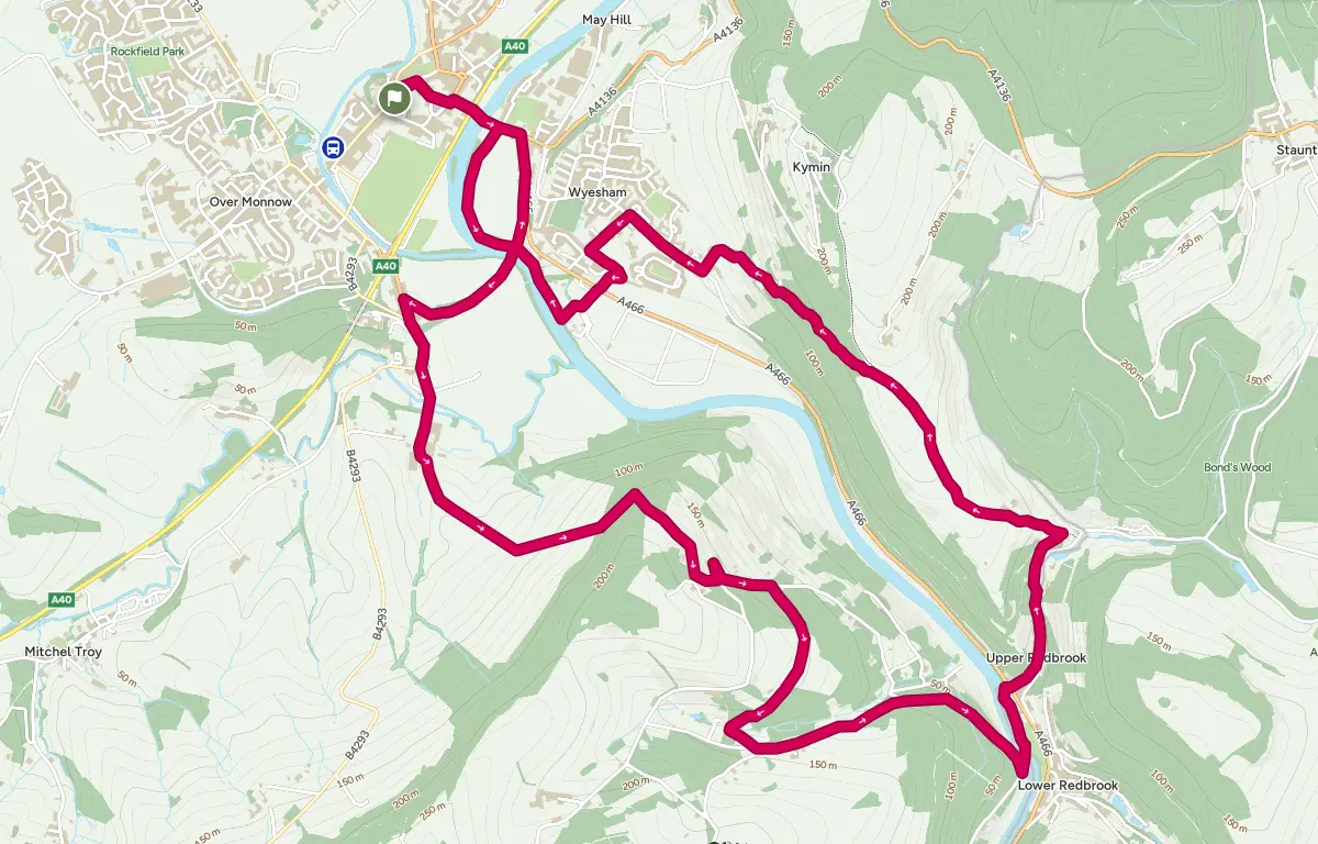
Commencing with a riverbank walk, this walk takes in several historic buildings including railway architecture, a Grade II listed 17th century mansion and a Grade I medieval church. En route there are views of the Wye Valley and Monmouth town.
Leave Agincourt Square via Church St. Turn right down St Mary’s St and at the end turn left and immediately right into Wyebridge St. Use the underpass to cross the A40 dual carriageway and cross the Wye Bridge. After the river crossing turn right into the car park for the Monmouth School sports ground. Pass the pavilion on your left to join the Wye Valley Walk, which follows the bank between the playing fields and the river. Immediately after the confluence of the Monnow and Wye, pass under a disused iron railway bridge then immediately turn left and mount the steps leading up to the trackbed of the disused Ross and Monmouth railway. Turn left and cross the bridge, taking the chance to admire the view over the river downstream toward the ruins of a magnificent multi-arched curving viaduct, which formerly carried the Wye Valley railway. Beyond this Livox Wood clothes the hill on the west side of the Wye valley – to be encountered more closely a little further on.
Beyond the iron bridge, follow the path along the old railbed leading to the site of Monmouth Troy station, closed in 1964 and dismantled, transported and reconstructed at Winchcombe on a restored line in Gloucestershire. After passing the one remaining brick-built hut, bear right across the yard to a narrow wicket gate into a small housing estate. Follow the estate road curving to the left, then turn left and left again onto the B4293, which passes over the short tunnel at the western exit from Monmouth Troy station. Follow the pavement by this busy road for about 200m, then when the road bends sharply right, continue straight on into the drive crossing the Trothy, a tributary of the Wye, and leading to the gates of the magnificent Troy House. Constructed in the 1680’s by the first Duke of Beaufort, this Grade II* listed mansion is now in a sad state of repair begging for an imaginative restoration.
Leaving Troy House on the left, pass through the farmyard of Troy Farm, bearing slightly left after the large barns on the left, then immediately slightly right to enter the broad lane leading uphill. Pass through the gate to the right of the hedge line and continue along the track, with good views of the viaduct and Monmouth beyond. The gradient slackens then steepens again toward the end of the track. At this point, enter the field to the left and traverse this diagonally upwards, looking out for the stile in the fence at the top of the field that gives access to Livox Wood. After crossing this stile, turn left on the frequently overgrown footpath for about 20m and then sharp right into the steeply rising and deeply indented path leading upward towards Penallt. When this starts to open out, bear right and then, as the gradient slackens, left to leave the wood some 145m (475 feet) above sea level and about 120m (400 feet) above the River Wye. Cross the bottom of three fields and pass through a gate onto a level green track running below some houses. Bear right to avoid entering a field part way along the track, then follow the track as it rises to the right to join the rough drive leading to the houses just passed. Turn left to follow the drive over the crest and down to meet the metalled road. Turn sharp left and follow the road to the lychgate of the Grade 1 listed medieval Penallt Old Church. Nestled in the lee of the hill, the quiet flower-rich churchyard offers a panoramic view of Monmouth, Lord’s Grove woods and Upper Beaulieu across the Wye valley, with the river far below.
Leaving the church and lychgate, continue along the road downhill for about 150m until reaching a footpath on the right, just before the house named Barberry. Take this pathupward, following the boundary wall on the left, until it emerges into a field. Cross this field keeping close to the hedge on the right as it curves round the hill, then continue as the path becomes a lane passing some farm buildings into a wood and descending increasingly steeply. On reaching a junction in the ways where the land meets the Black Brook, turn sharp left into a more substantial lane, and then left and left again as this rises to join increasingly broad – though quiet – roads, emerging opposite Glyn Farm. Follow the road downhill for about 1 km, passing the very steep lane on the left accessing the small settlement where the Black Brook valley debouches into the Wye valley, and then several small waterfalls on the right as the road passes beneath the steeply rising slope of Luggas Wood. On reaching the Boat Inn on the right at the foot of the slope, pass the pub then immediately double back to the left onto the footbridge bolted to the skeleton of the 1870’s Wye Valley Railway bridge spanning the Wye – and briefly enter England. This bridge, some 20m (65 feet) above sea level,offers picturesque views both of the Wye upstream and of Redbrook, located at the confluence of the Wye with several side valleys.
At its northern end the footbridgepasses under the trackbed and then rises up a ramp to the level of the former Redbrook Station. Turn sharp left and then left again to cross the line of the track, then down the side of the embankment to the path along the river bank – the lowest point on the walk. Follow this path to the right until it reaches the main A466, back in Wales. Turn right and then immediately left, up the road signposted Newland and Clearwell through the side valley containing the border with England. Especially after wet weather, listen for the sound of the powerful stream rushing down through a series of channels to the right of the road. From the early 18th century, Redbrook was the site of major tinplate works, one powered by this stream. The curious inclined stone bridge over the road, constructed in 1812 to supply these works and now Grade II listed, carried a “self-acting” branch off the horse-drawn tramway from Monmouth to Coleford, the weight of descending wagons being used to pull the empties up. As the road rises through the village, it passes a series of reservoirs formed to serve this industry.
About 500m after leaving the A466, follow the minor road forking left. The steep bank to the left carries the remains of both the tramway and a later railway route, including tunnels, opened in 1883 – but all were abandoned by 1917. The road crosses the former tramway shortly before it bends to the left, then immediately after the bend it crosses the portal of a short railway tunnel – now submerged in dense brambles, though its other end emerges in a well landscaped garden over to the right. Continue up the steepening lane to Jamie’s Farm, where the slope slackens somewhat but the surface becomes much rougher, before reaching the end of the hedge on the left. Here the lane becomes a ridgeway, part of Offa’s Dyke path, offering increasingly spectacular panoramic views as it progressively gains height,back over the Wye valley towards Llandogo and Tintern, to the right towards Newland and Bunjups Wood concealing Staunton and the Buck Stone, and to the left, across the Wye valley, to Livox Wood and Penallt, and beyond to Blorenge and the Sugar Loaf. The lane re-enters hedges on both sides shortly before reaching the crest by Redbrook Equestrian’s stables at Cockshoot Ash Barn. This is some 175m (574 feet) above sea level and 155m above the bridge at Redbrook. Leaving the buildings to the left, the track becomes a narrow footpath passing a gate on the right giving access to side paths toward Beaulieu Ridge and the Kymin. Continue straight on into woodland by Harper’s Grove. The footpath gradually descends, often wet and very rough under foot, but clearly long-established as a route – Wyesham Lane – between Wyesham and Redbrook. Shortly after passing an abandoned quarry on the right, the path becomes a metalled lane at the entrance to Sky Farm. Follow the lane down past the house on the right, pausing to admire its spectacular view over Wyesham towards Livox wood, with the Trothy valley beyond leading towards Raglan and Abergavenny beyond – as well as the snatch of poetry incised in slate on its terrace wall.
On leaving the woods, the lane bends right then left before reaching a T-junction with Wyesham Road. Turn right and follow the road past Kymin View primary school until, immediately before reaching St James’s church, turn left down Wyesham Avenue. Just before reaching the main A466, turn left into the small Church Farm cul-de-sac. At its end climb the ramp with disused stock pens on the right, and follow the path between the estate fence and an extensive bramble patch. This is the course of the former Wye Valley Railway, now discernible only by its raised course extending over the fields beyond the gate ahead. Turn right at the end of the bramble patch, cross the A466 and the field opposite. Follow the footpath passing to the right of the sewage treatment works and down the steps to meet the Wye Valley walk along the river bank. Turn right and follow the path skirting the bank, passing under the monumental stonework of a now-dismantled railway bridge. Close to the confluence between the Wye and the Monnow approaching from the west, mount the same steps leading to the trackbed emerging from a disused iron railway bridge as on the outward leg. However now turn right and follow the track toward the former Monmouth May Hill station. Descend the ramp to the right to join the pavement along the A466; turn left to follow the road and left again at the roundabout. Cross the Wye Bridge before using the underpass to cross the A40. Carry on to the end of Wyebridge St and turn left then right into St Mary’s St. At the top of St Mary’s St turn left into Church St and follow this back to Agincourt Square.